Not enough water to drown a man, not enough wood to hang him, and not enough soil to bury him. So claimed a henchman of Oliver Cromwell in the 1650s, describing the Burren region of western Ireland as British troops scoured the land searching for rebels to the Crown.
Lesser known is the rest of the Cromwellian’s observation: “And yet their cattle are very fat; for the grass growing in turfs of earth…that lie between the rocks, which are of limestone, is very sweet and nourishing."
Barren and bleak, bustling with life, the Burren is a place of contradictions.
The Burren is a 150 square mile region in County Clare, Ireland, famous for endless stretches of flat, rectangular limestone surface bedrock reaching to the horizon in all directions, tumbling into draws and scaling the low-lying mountains. Its name, appropriately, derives from an Irish word, "Boíreann," meaning “a rocky place.”
But from the crevices (called grykes) between the slabs (called glints) grow a wealth of spring and summer wildflowers. The flora includes arctic species hearty enough to withstand the cool, wet, wind-beaten winters as well as Mediterranean varieties that flourish in the rarely freezing Gulf-Stream-tempered climate. In mid-April the yellow primrose and cobalt-blue spring gentium were beginning to make their appearance alongside the endless gray slabs.
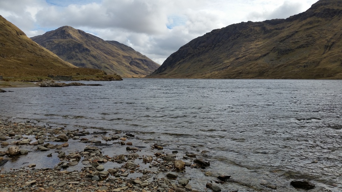
Bleak and treeless, the Burren holds an austere beauty. A rain-soaked region, its water disappears quickly underground, channeled through the porous limestone, so that the surface itself is dry (in contrast to the bogs), except for seasonal valley pools called turloughs that disappear back into the ground in summer when the water table drops.
The Burren began to take its present shape during the last ice age, ending 12,000 years ago, when glacial sheets stripped away much of the overlying soil. Stone-age farmers further depleted the topsoil with erosional farming practices, clearing forests from marginal lands. The limestone bedrock, now exposed at the surface, began to weather and crack in rectangular patterns. Since limestone is soluble over time, the cracks grew into crevices, and the remaining topsoil filtered into the spaces between the limestone blocks.
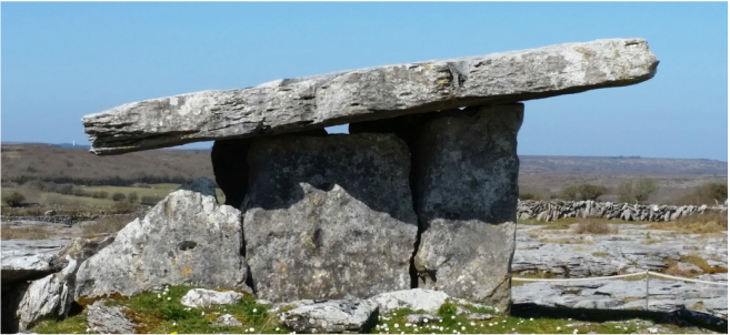
Remnants of stone-age (Neolithic) civilization still abound. Nearly a hundred portal tombs dot the Burren landscape. These tombs typically consist of two or three 6-8 foot tall limestone slab-walls set vertically, supporting a roof slab, giving the appearance of a tottering house of cards, although they have remained stable through 5,000 years of weathering.
Likewise, the ruins of medieval Celtic Christian monasteries abound, both in the Burren proper and in its topographical extension onto the nearby Aran Islands. While many Celtic monasteries found the Holy in bountiful surroundings like Glendalough beside a mountain lake or Clonmacnoise along the River Shannon, other monasteries—or monks at the start of their journeys—sought the Holy in remote, austere places. As modern-day self-proclaimed Celtic monk Dara Molloy explains, monks would often wander before they settled down, “looking for their ‘place of resurrection’.” They were inspired by the desert monks of ancient Egypt and gave place names like Disert and Dysart to the most austere localities. In the Burren and Aran Islands, there was little to distract them from their inward journeys.
While Neolithic tombs and monastic ruins are tucked away in corners of the wandering back roads, the Burren owes its modern look to grazing cattle. If early farmers had destroyed their own nest, the lush grasses that grew in pockets and clumps among the stony slabs nourished the cattle that Celtic kings—and later Norman and British landowners—boasted as the essence of Irish wealth. In turn, cattle kept the underbrush trimmed back which, left unchecked, might in time have covered the rocky expanse and perhaps built up a new soil.
Even so, farmers didn’t give up the fight against the expanse of rock. Where the Burren meets the coast and on the nearby islands, Irish peasants scooped up handfuls of soil that had built up in the crevices, blended it with sand and seaweed, and carted the mixture to their small parcels of land amid the British landlords’ grazing estates. Here, from the rocky, barren place, they built, inch by inch, the garden parcels that sustained them through centuries of indentured poverty.
But when the potato blight hit in the 1840s, disease destroyed away their main crop. The British continued exporting the cattle while starvation and immigration carried away the population. Today, the Burren’s population is still less than 60% of its pre-Famine level.
The Burren is popular with tourists, although much of its traffic is en route to the Cliffs of Moher, one of Ireland’s most famous attractions. The curious will stop to examine the Poulnabrone portal tomb. For a taste and smell of the old ways, many will stop in the peat-warmed pubs of nearby Doolin and Listoovarna for a pint and a bowl of Irish stew, staking out a nook amid meandering rooms. The evenings are filled with traditional music.
But driving on the one-lane back roads in the off-season, you will encounter the day’s only traffic, a local tractor that will require you to back up 100 feet before one or the other of you can pull slightly off the road to let the other pass. A guided hike across the stony uplands will reveal the first of the season’s wildflowers taking hold against the limestone pavement. Your eye will sweep toward the turloughs that will disappear in summer like so much mist. Away from the touring buses, sheep and cattle guard the less-visited stony ruins of the ages.
The Burren is a study in contrasts. Barren yet bustling with life, ancient and depopulated yet alive with Irish heritage, it doesn’t quickly reveal the full depth of its contradictions. For that, you must look between the rocks.
Lesser known is the rest of the Cromwellian’s observation: “And yet their cattle are very fat; for the grass growing in turfs of earth…that lie between the rocks, which are of limestone, is very sweet and nourishing."
Barren and bleak, bustling with life, the Burren is a place of contradictions.
The Burren is a 150 square mile region in County Clare, Ireland, famous for endless stretches of flat, rectangular limestone surface bedrock reaching to the horizon in all directions, tumbling into draws and scaling the low-lying mountains. Its name, appropriately, derives from an Irish word, "Boíreann," meaning “a rocky place.”
But from the crevices (called grykes) between the slabs (called glints) grow a wealth of spring and summer wildflowers. The flora includes arctic species hearty enough to withstand the cool, wet, wind-beaten winters as well as Mediterranean varieties that flourish in the rarely freezing Gulf-Stream-tempered climate. In mid-April the yellow primrose and cobalt-blue spring gentium were beginning to make their appearance alongside the endless gray slabs.
Bleak and treeless, the Burren holds an austere beauty. A rain-soaked region, its water disappears quickly underground, channeled through the porous limestone, so that the surface itself is dry (in contrast to the bogs), except for seasonal valley pools called turloughs that disappear back into the ground in summer when the water table drops.
The Burren began to take its present shape during the last ice age, ending 12,000 years ago, when glacial sheets stripped away much of the overlying soil. Stone-age farmers further depleted the topsoil with erosional farming practices, clearing forests from marginal lands. The limestone bedrock, now exposed at the surface, began to weather and crack in rectangular patterns. Since limestone is soluble over time, the cracks grew into crevices, and the remaining topsoil filtered into the spaces between the limestone blocks.
Remnants of stone-age (Neolithic) civilization still abound. Nearly a hundred portal tombs dot the Burren landscape. These tombs typically consist of two or three 6-8 foot tall limestone slab-walls set vertically, supporting a roof slab, giving the appearance of a tottering house of cards, although they have remained stable through 5,000 years of weathering.
Likewise, the ruins of medieval Celtic Christian monasteries abound, both in the Burren proper and in its topographical extension onto the nearby Aran Islands. While many Celtic monasteries found the Holy in bountiful surroundings like Glendalough beside a mountain lake or Clonmacnoise along the River Shannon, other monasteries—or monks at the start of their journeys—sought the Holy in remote, austere places. As modern-day self-proclaimed Celtic monk Dara Molloy explains, monks would often wander before they settled down, “looking for their ‘place of resurrection’.” They were inspired by the desert monks of ancient Egypt and gave place names like Disert and Dysart to the most austere localities. In the Burren and Aran Islands, there was little to distract them from their inward journeys.
While Neolithic tombs and monastic ruins are tucked away in corners of the wandering back roads, the Burren owes its modern look to grazing cattle. If early farmers had destroyed their own nest, the lush grasses that grew in pockets and clumps among the stony slabs nourished the cattle that Celtic kings—and later Norman and British landowners—boasted as the essence of Irish wealth. In turn, cattle kept the underbrush trimmed back which, left unchecked, might in time have covered the rocky expanse and perhaps built up a new soil.
Even so, farmers didn’t give up the fight against the expanse of rock. Where the Burren meets the coast and on the nearby islands, Irish peasants scooped up handfuls of soil that had built up in the crevices, blended it with sand and seaweed, and carted the mixture to their small parcels of land amid the British landlords’ grazing estates. Here, from the rocky, barren place, they built, inch by inch, the garden parcels that sustained them through centuries of indentured poverty.
But when the potato blight hit in the 1840s, disease destroyed away their main crop. The British continued exporting the cattle while starvation and immigration carried away the population. Today, the Burren’s population is still less than 60% of its pre-Famine level.
The Burren is popular with tourists, although much of its traffic is en route to the Cliffs of Moher, one of Ireland’s most famous attractions. The curious will stop to examine the Poulnabrone portal tomb. For a taste and smell of the old ways, many will stop in the peat-warmed pubs of nearby Doolin and Listoovarna for a pint and a bowl of Irish stew, staking out a nook amid meandering rooms. The evenings are filled with traditional music.
But driving on the one-lane back roads in the off-season, you will encounter the day’s only traffic, a local tractor that will require you to back up 100 feet before one or the other of you can pull slightly off the road to let the other pass. A guided hike across the stony uplands will reveal the first of the season’s wildflowers taking hold against the limestone pavement. Your eye will sweep toward the turloughs that will disappear in summer like so much mist. Away from the touring buses, sheep and cattle guard the less-visited stony ruins of the ages.
The Burren is a study in contrasts. Barren yet bustling with life, ancient and depopulated yet alive with Irish heritage, it doesn’t quickly reveal the full depth of its contradictions. For that, you must look between the rocks.